Not Those Minutes!
Today in class we discussed and defined lines of latitude and longitude. Shortly after that, we touched upon the subject of minutes and seconds on a geographic scale.
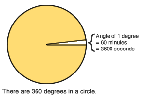

Lets first talk shortly about what we learned about regarding minutes and seconds in terms of degree measurements.
Notice how above is a complete circle, 360°, as if you were looking at our earth from one angle. Now take that 360° and divide it by 360, hopefully, you got 1°. Within that 1° in order to better pinpoint a location, minutes and seconds can be used. Just as minutes and seconds in time, there are 60 minutes which make up 1° and within each minute contains 60 seconds; totaling to 3,600 seconds in a degree.
So now let's discuss our other point in class, latitude, and longitude. We'll start with defining each.
Latitude- Sometimes known as parallels, latitude is used to measure north and south degrees.
The common known Equator line is considered a line of latitude. That is the parallel on the left colored red in the picture below.

Longitude- Sometimes known as meridians, longitude is used to measure east and west degrees.
The common known prime meridian is a line of longitude. That is meridian in red on the right on the latitude vs longitude picture.
Latitude and Longitude can be used to measure coordinates and by using minutes and seconds, we can gather an even more precise location of a specific point.
That concludes my September 27th Blog Post, till next time!

Comments
Post a Comment